|
The OCTS sensor carried out highly sensitive spectral observations of the ocean with eight visible and near-infrared channels and four thermal infrared channels. The sensor swath was about 1400km, which covered the entire surface of the earth in 3 days with a spatial resolution of 700m at the surface. Although the lifetime of ADEOS was relatively short (about 10 months), OCTS left a huge invaluable data set for the progress of oceanography. The OCTS main targets are 1) Chl-a, 2) Sea Surface Temperature (SST) of the global oceans, and 3) Land vegetation index. Because of the unique characteristics of the ADEOS mission, OCTS data will continue to be of immense value to the oceanographic community.
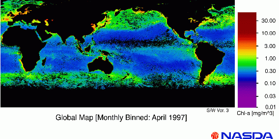
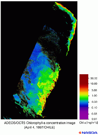
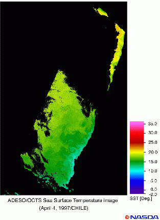
The OCTS team at NASDA has been working on the generation of OCTS data products. Version-3.0 of the algorithm used to estimate Chl-a and SST was completed in November, 1997. Figure 1 shows the monthly Chl-a distribution in the global oceans for April, 1997. The high quality of the OCTS Chl-a field is apparent, capturing characteristic Chl-a distribution patterns in the global oceans. Figure 2 shows the OCTS Chl-a distribution in the Pacific Ocean off Peru and Chile at a high spatial resolution (700m). Along the coastline, high concentrations of Chl-a are observed; an eddy-like structure is prominent off the Patagonia coast and a wavy pattern reminiscent of the K-H instability is seen off the coast of northern Chile. Figure 3 depicts the SST image with a spatial resolution of 700m obtained at the same time as the Chl-a image of Figure 2. Although the patterns in both images are similar, the detailed features are not the same. These images demonstrate the characteristics and capability of OCTS as a powerful tool for oceanography. The OCTS images presented here can be obtained through ftp from NASDA/EORC (http://www.eorc.nasda.go.jp). Information on the new products and various sample images are also available from the Web site. The version 3.0 Chl-a and SST products for the global oceans have been released by NASDA/EOC (http://www.eoc.nasda.go.jp/). Intensive LAC products for specific coastal oceans (700m resolution) are also available from NASDA/EORC.
OCTS Team
Earth Observation Research Center/NASDA,
Roppongi First Building, 1-9-9,
Roppongi, Minato-ku, Tokyo 106, Japan
Hiroshi KAWAMURA
(Leader)
kamu@ocean.caos.tohoku.ac.jp
Masanobu SHIMADA
(Sub leader)
shimada@eorc.nasda.go.jp
Yasuhisa NAKAMURA
(Sub leader)
nakamura@eorc.nasda.go.jp
Hiromi Oaku
(Calibration-group leader)
oaku@eorc.nasda.go.jp
Yasushi MITOMI
(Algorithm-group leader)
mitomi@eorc.nasda.go.jp
Akira MUKAIDA
(Validation-group leader)
mukaida@eorc.nasda.go.jp
Hiroshi Murakami
(Application-group leader)
murakami@eorc.nasda.go.jp
This article appeared in the
Febuary 1998 issue of the backscatter magazine, published by the
Alliance of Marine Remote
Sensing
|
|
Figure 2. Chl-a distribution in the Pacific Ocean off Peru and Chile on 4
April, 1997. The image has the highest spatial resolution of 700m.
|
|
Figure 3. SST distribution in the Pacific Ocean off Peru and Chile on 4
April, 1997. The image has the highest spatial resolution of 700m.
|
|