

This article has been commissioned by the IOCCG and
has appeared in the backscatter magazine,
published by the Alliance
of Marine Remote Sensing (AMRS)
INTRODUCTION
The Sensor Intercomparison for Marine Biological and Interdisciplinary Ocean Studies (SIMBIOS) program was conceived in 1994 as a result of a NASA management review of the agency's strategy for monitoring the bio-optical properties of the global ocean through ocean color remote sensing from space. At the time, the NASA ocean color flight manifest included two data buy missions, SeaWiFS and EOS Color, and two sensors, MODIS and MISR, scheduled for flight on the EOS AM (1998) and PM (2001) satellites. The principal question of the review was whether NASA should invest in the EOS Color mission when five additional ocean color systems with similar global capabilities (OCTS, Japan; GLI, Japan; POLDER-1 and -2, France; and MERIS, European Space Agency) and several other non-global missions by Argentina, Germany, Taiwan, India, Korea, the U.S. Navy, and the People's Republic of China, were planned for launch during the late 1990s. The review led to a decision that the international assemblage of ten ocean color satellite systems provided ample redundancy to assure continuous global coverage, with no need for an additional NASA-funded instrument and satellite. At the same time, it was noted that non-trivial technical difficulties attended the challenge (and opportunity) of combining ocean color data from this array of independent satellite systems to form consistent and accurate global bio-optical time series products. Thus, it was decided to redirect some of the resources budgeted for EOS Color into an intercalibration and validation program. The decision resulted in international organizational meeting in February 1995, to draft an initial plan, the release of a NASA Research Announcement (NRA) in 1996, and the establishment of the SIMBIOS Project Office at the NASA Goddard Space Flight Center (GSFC) in 1997 (collocated with the SeaWiFS Project Office).
|
The initial SIMBIOS program is scoped for five years (1997-2001) and includes support for the science team (NRA selections) and the project office. In 1995, the International Ocean Colour-Coordinating Group (IOCCG) was formed to undertake the organization of an international SIMBIOS program. The IOCCG presently operates under the auspices of the Scientific Committee on Oceanic Research (SCOR) and chairmanship of Dr. Trevor Platt.
Radiometric comparison experiments conducted by the SeaWiFS Project, with participation of the National Institute for Standards and Technology (NIST), clearly demonstrated that significant effort would be necessary to quantify the traceability of calibrations of several sensors to a common scale of spectral radiance. Moreover, a coordinated radiometric validation effort would be needed to detect and quantify changes in radiometric responsivity of each sensor during its operational lifetime on orbit. Plans to combine estimates of chlorophyll-a, and other ocean bio-optical products, would require cross-validation of the various algorithms being used operationally by the different flight projects. Also, research must be initiated to develop appropriate methods for combining radiometric and derived bio-optical products from sensors with different viewing geometries, resolutions (spatial, temporal, and spectral), and other radiometric characteristics. Many of these issues are addressed by each ocean color instrument team as they apply to their particular mission, but the teams are not chartered or funded to examine data from other missions. The SIMBIOS program is meant to foster information exchange and collaboration between missions and to complement and assist in the validation efforts of the individual ocean color projects.
|
The NASA SIMBIOS PROGRAM
The NASA program consists of the SIMBIOS Science Team and the SIMBIOS Project Office. The SIMBIOS Science Team, as initially defined by the NRA selections, was expanded to include additional investigations for atmospheric correction algorithm validation. The SIMBIOS program is substantially augmented by the participation of the NASA-supported MODIS Oceans Team and SeaWiFS Calibration and Validation program. Table 1 provides the names and affiliations of the principal investigators including those associated with the MODIS and SeaWiFS projects. Note that there are many other co-investigators and collaborators on the team. The locations of specific investigations are shown in Figure 1. SIMBIOS collaborators associated with other relevant programs and science teams who contribute data, algorithms, etc., are given access to SIMBIOS Project resources in return, e.g., access to the SeaWiFS Bio-optical Archive and Storage System (SeaBASS).
Besides providing administrative and contract support for the science team, the SIMBIOS Project Office is scoped to support four primary activities: 1) data product validation, 2) sensor calibration, 3) data merger algorithm evaluation, and 4) satellite data processing. The data processing facility is operational and is scaled for limited data storage (in situ and satellite),
|
product generation, and analyses support as required for SIMBIOS specific investigations. The system will be used for processing OCTS high-resolution coastal U.S. data.
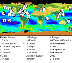
Figure 1 : Global distribution of the NRA-selected SIMBIOS field studies. Field studies supported by the MODIS Oceans Team and the SeaWiFS Project are not shown.
|
Data Product Validation
Validation is the process of determining the spatial and temporal error fields of a given biological or geophysical data product and includes the development of comparison or match-up data sets, i.e., field observations and satellite data coincident in time and location. The primary objective of SIMBIOS is identifying biases between regions and between similar products generated by the various missions. Validation field studies are being conducted by the SIMBIOS Science Team, the data from which is incorporated into SeaBASS. The SIMBIOS Project is presently providing SeaWiFS and MOS overflight predictions to help investigators in the field synchronize their optical data collection with the satellite overpasses.
The SIMBIOS Project has created a pool of ocean bio-optical instruments, the use of which will be shared between NASA-supported, U.S. investigators contributing to the SIMBIOS program. This "Instrument Pool" is an attempt to provide a cost-effective enhancement to the overall capabilities of the SIMBIOS Science Team, and to provide backup in case of failure of a critical instrument during an experiment. The equipment in the Instrument Pool are purchased and maintained by individual SIMBIOS principal investigators, but deployment schedules and priorities are coordinated by the Project Office with the advice of the Science Team.
|
Validation is the process of
determining the
spatial and temporal error
fields of a given
biological or geophysical
data product ...
To better support validation of algorithms for atmospheric corrections and aerosol property retrievals, the SIMBIOS Project Office has established a close working collaboration with the Aerosol Network (AERONET) project, which maintains and operates a worldwide network of sun-tracking photometers. The NASA AERONET program is managed GSFC personnel. The Project Office has purchased equipment for nine additional island and coastal sun-photometer stations to be added to the AERONET, and has linked the AERONET archives to SeaBASS. In addition, the Project Office maintains a pool of hand-held sun photometers, which are calibrated by the GSFC AERONET investigators and are made available to SIMBIOS investigators during field experiments.
|
Sensor Calibration
Calibration is the process of determining the functions and coefficients necessary to convert sensor output values (voltages or counts) into radiometric units. A calibration program includes both prelaunch (laboratory characterization) and on-orbit components, and it can include direct (e.g., internal lamps, solar diffuser observations, and lunar images) and indirect (vicarious) methods. Because of the possible degradation of sensor response over time, the calibration program must continue throughout the life of a mission. The purpose of the SIMBIOS calibration program is to review prelaunch and on-orbit calibration data available from the various satellite missions, to complement their activities with
Calibration is the process
of determining the functions
and coefficients necessary to
convert sensor output values
(voltages or counts) into
radiometric units.
|
additional analyses or alternative approaches, and to provide an independent assessment of the data to them.
To verify the uncertainties of calibrations for in situ radiometric data included in the SeaBASS data archives and used for SIMBIOS validation analyses, the Project Office will continue periodic calibration round-robin intercomparison experiments. This follows a similar activity originated by the SeaWiFS Project. Each year, a pair of both radiance and irradiance field sensors are transported by a representative of the Project Office to the laboratories whose personnel calibrate the field radiometers used in SIMBIOS ocean optics validation experiments. These laboratories include instrument manufacturers, government laboratories, and academic institutions who actively calibrate field radiometers used in the SIMBIOS program. The purpose of this comparison is to determine the interlaboratory uncertainty in calibration sources and procedures, and to detect and correct problems at any individual laboratory in a timely fashion. The first such round-robin intercomparison in 1997 included visits to four foreign and six U.S. facilities and indicates that, as a community, calibrations fall within an uncertainty of within 2% for radiance and 1% for irradiance.
|
Data Merger
The objective of the data merger component is to develop and test methods of combining data from different sources to provide time series of global fields. Sources may have different inherent spatial and temporal resolutions and different methods may be required depending on the geophysical quantity, e.g., chlorophyll-a, water-leaving radiance, primary productivity, etc. Data merger algorithm development is the focus of two SIMBIOS science team investigations, both of which are in the very early phases of design and evaluation.
At the present time, the SIMBIOS Project is actively working on OCTS, POLDER, MOS, and SeaWiFS data in collaboration with the respective space agencies and science teams. In addition, the Project is planning to incorporate a MOS data acquisition subsystem into the SeaWiFS HRPT station at GSFC by this summer. |
The Project is also preparing to support the MODIS Oceans Team as the EOS AM platform is scheduled for launch later this year.
In one sense, the SIMBIOS Project is a programmatic experiment by NASA. In lieu of initiating a flight project, the agency seeks to enable the international ocean color community to aggregate data from the assemblage of already planned sensors by providing some of the resources that will be required to merge and validate the various global data products. As such, the NASA SIMBIOS program amounts to a U.S. contribution to goals and objectives that can only be fully realized, however, in the context of a truly international effort. For more information on the NASA SIMBIOS program, check the Project Office homepage,
http://simbios.gsfc.nasa.gov/.
|
Table 1. NASA SIMBIOS Science Team Principal Investigators.
The P.I. list is composed of those selected under the NRA, some members of the MODIS Oceans Team, and certain members the SeaWiFS Project. There are many more U.S. and international co-investigators and collaborators actively participating in the NASA component of the international SIMBIOS program.
I. Ocean Bio-optical and
Sensor Characterization
Studies
K. Arrigo (NASA)
J. Brock (NOAA)
C. Brown (NOAA)
D. Capone (U. of Maryland)
E. Carpenter (State U. of New York)
K. Carder (U. South Florida)
F. Chavez (Monterey Bay Aquarium Res. Inst.)
D. Clark (NOAA)
G. Cota (Old Dominion U.)
T. Dickey (U. of California/Santa Barbara)
M. He (Peoples Republic of China, Ocean U. of Qingdao)
W. Esaias (NASA)
D. Eslinger (U. of Alaska)
R. Evans (U. of Miami)
|
R. Green (Jet Propulsion Lab.)
R. Frouin (Scripps Inst. Oceanogr.)
F. Hoge (NASA)
S. Hooker (NASA)
O. Kopelevich (Soviet Union, P.P. Shirshov Inst. of Oceanology)
G. Korotaev (Ukraine, Marine Hydrophysical Inst.)
H. Li (Taiwan, Nat. Taiwan Ocean U.)
R. Miller (NASA)
G. Mitchell (Scripps Inst. of Oceanogr.)
J. Mueller (San Diego State U.)
F. Mueller-Karger (U. South Florida)
S. Saitoh (Japan, Hokkaido U.)
D. Siegel (U. of California/Santa Barbara)
R. Zaneveld (Oregon State U.)
II. Data Merger Studies
W. Gregg (NASA)
D. Siegel (U. of California/Santa Barbara)
III. Atmospheric Correction Studies
P. Flateau (Scripps Inst. of Oceanogr.)
H. Gordon (U. of Miami)
M. Miller (Brookhaven National Lab.)
J. Porter (U. of Hawaii)
K. Stamnes (U. of Alaska)
|
| Acronyms | . |
| EOS | Earth Observing System |
| GLI | Global Line Imager |
| HRPT | High Resolution Picture Transmission |
| MERIS | Medium-Resolution Imaging Spectrometer |
| MISR | Multi-angle Imaging Spectroradiometer |
| MODIS | Moderate Resolution Imaging Spectroradiometer |
| MOS | Modular Optoelectronic Scanner |
| POLDER | Polarization and Directionality of Earth's Reflectances |
| SeaWiFS | Sea-viewing Wide Field-of-view Sensor |
This article appeared in the
May 1998 issue of the backscatter magazine, published by the
Alliance of Marine Remote
Sensing
[ IOCCG Home Page]
|