|
|
|
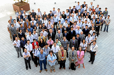
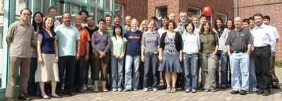
Dr. Roland Doerffer of the GKSS Research Centre, Germany, conducted an advanced IOCCG training course/workshop on Inversion Procedures in Ocean-Colour Remote Sensing. The course took place in Lauenburg, Germany from 10-14 August 2009 and as attended by 27 participants from 18 countries. All the students agreed that the course was extremely helpful for their ongoing research, and that the lecturers did an excellent job (Roland Doerffer, ZhongPing Lee, Mark Dowell, Stewart Bernard and Harald Krawczyk) - our thanks to the team. The course dealt with complex waters with different optical components, and provided participants with an overview of inversion methods and models, and taught them how to use various inversion techniques. For further details of the course, please see the training course website, or read the summary of the training course.
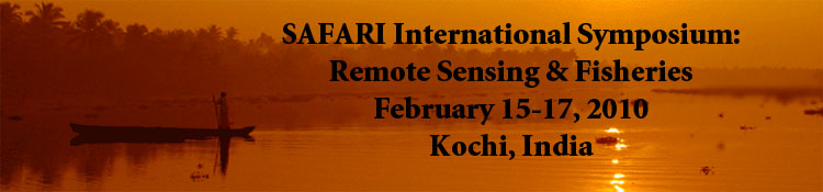
The SAFARI Initiative (Societal Applications in Fisheries and Aquaculture Using Remotely-Sensed Imagery), funded by the Canadian Space Agency (CSA), is organizing an international symposium on Remote Sensing and Fisheries, in conjunction with the IOCCG. The symposium is scheduled to take place in Kochi, India from 15-17 February 2010 and is co-sponsored by CSA, IOCCG, CIFT (Central Institute of Fisheries Technology) and POGO. Case studies using Earth observation data to address various aspects of fisheries systems around the world will be addressed. Themes will include:
Invited speakers include Drs. Kenneth Sherman, Shailesh Nayak, Jeffrey Polovina, Cara Wilson, Sei-Ichi Saitoh, Simon Jennings and Emmanuel Chassot.
Following the symposium (18-19 February 2010) there will be a meeting of the Chlorophyll Global Integrated Network (ChloroGIN) project, which aims to promote in situ measurement of chlorophyll in combination with satellite derived estimates. The deadline for registration is 15 October 2009, so interested participants are requested to register promptly. Further information about the symposium, including registration details, can be found at: www.geosafari.org/kochi or by emailing info@geosafari.org. A monograph on this topic entitled "Remote Sensing in Fisheries and Aquaculture" will be published by the IOCCG later this year as part of the IOCCG series of reports.
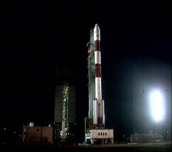
The Indian Space Research Organisation (ISRO) will launch Oceansat-2 later this month (September 2009). Oceansat-2 is a unique integrated satellite based on ocean colour and wind vectors, designed to identify potential fishing zones (PFZs), assist in coastal zone studies and provide inputs for weather forecasting and climate studies. All pre-launch tests on the functional aspects of the satellite have been successfully completed. Oceansat-2 will blast off on board India's Polar Satellite Launch Vehicle (PSLV) from the Satish Dhawan Space Centre (SDSC) on the east coast of India. This satellite will be an in-orbit replacement to Oceansat-1, which was launched by ISRO in May 1999 to study physical and biological aspects of oceanography. Oceansat-2 will carry an Ocean Colour Monitor (OCM), a Scatterometer and a Radio Occultation Sounder for Atmospheric Studies (ROSA).
Several new positions have been added to the Employment Opportunities section of the IOCCG website, including a Canada Excellence Research Chair in Remote Sensing of the Arctic at Laval University (Quebec City, Canada), a Principal Investigator at Bigelow Laboratory for Ocean Sciences (USA), an open rank position of research scientist at Lamont Doherty Earth Observatory (Columbia University, USA) and Post-Doctoral positions at the University of Maryland (USA) and LEGI (Grenoble, France).
|
NASA recently released SeaDAS version 5.4 which contains a number of enhancements including the ability to process MERIS data at both full (300 m) and reduced (1 km) resolution (in addition to the already released capability to display and analyze the official ESA-produced MERIS products). However, the processing capability within SeaDAS DOES NOT attempt to reproduce the official ESA-produced MERIS products. More specifically, the MERIS processing capability available in SeaDAS uses the NASA ocean colour atmospheric correction and derived-product algorithms, so results will differ from the standard MERIS processing performed by ESA. The intent is to provide a mechanism for processing MERIS, MODIS, SeaWiFS, OCTS and CZCS radiances to derived geophysical products using common algorithms, and also to allow SeaDAS users to investigate new products and applications that can be developed using the additional wavelengths and 300-meter resolution that MERIS offers. This version is a preliminary release. No attempt has yet been made to vicariously calibrate the algorithm or validate the results. The SeaDAS 5.4 release notes can be found here: http://oceancolor.gsfc.nasa.gov/forum/oceancolor/topic_show.pl?tid=2968.

NASA's Ocean Biology Processing Group (OBPG) is about to reprocess all ocean colour missions currently supported, including SeaWiFS, MODIS on Aqua and Terra, OCTS,and CZCS. Over the past year, the team has been working to identify and evaluate potential processing changes. These include sensor-specific calibration and characterization updates, sensor independent algorithm revisions, updated ancillary data sources, and product format and content changes. Major algorithm revisions include new aerosol models and model selection methodology, new Rayleigh tables, updated out-of-band corrections and band-averaged absorption and scattering coefficients, additional correction for NO2 absorption, and updates to the standard Kd and chlorophyll algorithm coefficients. A web site detailing the planned reprocessing changes can be found at: http://oceancolor.gsfc.nasa.gov/REPROCESSING/R2009/.
The Dragon-2 symposium recently took place in Barcelona where ongoing research projects using data from ESA and Chinese Earth observation satellites were discussed. The Dragon-2 programme has greatly enhanced EO capabilities within China and has cultivated an extensive team of young scientists working in remote sensing. Under Dragon-2, more than 400 scientists from 165 research institutions in Europe and China are involved in 25 joint research projects covering themes such as renewable resources, oceanography, hazards, coastal-zone monitoring and calibration and validation of satellite data etc. The Dragon Programme formally began in 2004 and was slated to end in 2008, but based on the success of the first phase, the programme was extended until 2012.
ESA and EUMETSAT (European Organisation for the Exploitation of Meteorological Satellites) recently signed a Framework Agreement on the Global Monitoring for Environment and Security (GMES) Programme. This Agreement is a major step in the implementation of the GMES Programme under the overall responsibility of the European Commission. It is based upon two decades of successful cooperation between ESA and EUMETSAT in meteorology, and opens up avenues for delivering operational services in new areas such as Environment and Climate Change. GMES is a user-driven initiative that aims to maximize the use of existing space and non-space observation capacities and services in Europe, including EUMETSAT. In this context ESA�s role is that of development and procurement for the dedicated Sentinel missions and coordinator of the overall GMES Space Component. EUMETSAT contributes to GMES core services with data from its satellites and will also contribute with data and products from its future missions. In addition it will operate some elements of the Sentinel satellites, such as the Sentinel-3 marine element which includes the Ocean Land Colour Instrument (OLCI).
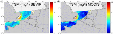
Several new references have been added to the IOCCG Recent References list, including a paper by Griet Neukermans and colleagues entitled "Mapping total suspended matter from geostationary satellites: a feasibility study with SEVIRI in the Southern North Sea� which recently appeared in Optics Express.
Currently there are no geostationary ocean-colour sensors in orbit, although South Korea plans to launch the GOCI ocean-colour sensor onboard the geostationary COMS-1 satellite early next year. This study by Neukermans et al. provides a proof-of-concept for the mapping of Total Suspended Matter (TSM) in turbid coastal waters from a geostationary platform using the SEVIRI meteorological sensor on the METEOSAT platform. Data are available from SEVIRI in near real time every 15 minutes, and although SEVIRI lacks sufficient bands for chlorophyll remote sensing, its spectral resolution is sufficient for quantification of TSM in turbid waters, using a single broad red band, combined with a suitable near infrared band. Total suspended matter was mapped in the southern North Sea over 35 consecutive days using a single-band TSM retrieval algorithm, calibrated by nonlinear regression of seaborne measurements of TSM and marine reflectance. Results indicated that mapping of TSM with SEVIRI was feasible for turbid waters, although there were considerable uncertainties in clearer waters. Furthermore, the TSM maps were well correlated with TSM maps obtained from MODIS AQUA. In addition, on cloud-free days, high frequency dynamics of TSM could be detected (see animation). Download full article in PDF format. |
|
Material for possible inclusion in the IOCCG Newsletter should be submitted to the Project Scientist, Dr. Venetia Stuart
Subscription to the IOCCG Mailing List. Participants receive a brief summary of the IOCCG Newsletter by e-mail (quarterly), as well as hard copies of IOCCG Reports as, and when, they become available.
|
|
|
|
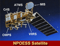 This month the White House will decide on proposed changes to the troubled National Polar-orbiting Operational Environmental Satellite (NPOESS) program which may include re-assigning management responsibility for the tri-agency effort. NPOESS will carry the VIIRS ocean colour sensor, and is funded by the U.S. Defense Department and NOAA, and managed by an Integrated Program Office. Originally planned for launch in 2009, the first NPOESS satellite is now scheduled to fly in 2014. A precursor satellite dubbed the NPOESS Preparatory Project (NPP), which was originally supposed to serve as a test for the primary NPOESS sensors, is now scheduled for launch in 2011, and will be thrust into an operational role because of the delays. An investigation team agreed that the current tri-agency management structure has not worked, and a number of possible options are being examined to bring these future weather satellites back on track.