SeaWiFS Data Available at the GSFC DAAC
Dr. James G. AckerOcean Color Data Support Team
NASA Goddard Space Flight Center
Greenbelt MD 20771
E-mail: acker@daac.gsfc.nasa.gov
This article was commissioned by the IOCCG.
On August 1, 1997, the Sea-viewing Wide Field-of-view Sensor (SeaWiFS) was launched on the OrbView-2 satellite. On the ground, this launch accelerated final preparations at the Goddard Space Flight Center Distributed Active Archive Center (GSFC DAAC) to insure that the system would be ready to receive, archive and distribute data processed by the SeaWiFS Project (http://seawifs.gsfc.nasa.gov/SEAWIFS.html). Over the next month, as the altitude of the satellite was raised incrementally to a 705 km altitude circular orbit, the GSFC DAAC tested the resilience and capabilities of the data handling software and hardware using simulated data created and sent by SeaWiFS Project.
On September 4, the sensor was turned on, and it delivered an engineering test image of the coastal regions of Maryland, Virginia, Delaware, Pennsylvania and North Carolina back to the SeaWiFS ground station at GSFC. This long-awaited benchmark was followed by two weeks of testing and tuning, leading to the commencement of full-time operations on September 18, 1997. On September 24, the first real SeaWiFS data were transferred to the DAAC from the SeaWiFS Project. Less than 14 hours later, researchers were able to utilize the GSFC DAAC's World Wide Web SeaWiFS data Browser to view and order real SeaWiFS data online.
SeaWiFS is now producing data at a rate unprecedented in the history of oceanographic remote sensing, providing scientists with a nearly comprehensive global view of the oceans every two days. Creating a system to receive this volume of data, organize the diversity of data products, and then make all of the products easily and quickly available to the research community was the culmination of over five years of planning and cooperation between the SeaWiFS Project and the DAAC. From the inception of SeaWiFS to its realization, one of the guiding standards of the program has been to make the data consistently available to the community within 24 hours or less from the time it is transferred to the DAAC.
SeaWiFS data comes in a variety of "flavors", suited to differing research requirements. Level 1A products contain radiances measured by the instrument across each scan line along the orbital trajectory.
Local Area Coverage (LAC) products have a spatial resolution of 1.1 km and consist of direct broadcast SeaWIFS data that are captured by High Resolution Picture Transmission (HPRT) ground stations situated throughout the world. Due to the finite reception area of these stations the HRPT LAC data are inherently regional in spatial coverage. Global Area Coverage (GAC) Level 1A products include the complete set of 14 orbits per day, but with a lower spatial resolution (4.5 km) than LAC (i.e., LAC data subsampled every 4th scanline, every 4th pixel).
Level 2 GAC products contain the actual geophysical parameters of interest derived from the level 1A GAC radiance data. A total of 12 parameters derived using atmospheric correction and bio-optical algorithms developed through NASA-sponsored research are available. These include normalized water-leaving radiances at 412, 443, 490, 510, and 550 nm; chlorophyll a concentration; "CZCS-type" pigment concentration; aerosol radiances at 670 and 865 nm; the diffuse attenuation coefficient at 490 nm (K490); the epsilon of the aerosol correction at 765 and 865 nm; and the aerosol optical thickness at 865 nm.
Level 3 products contain data that have been "binned" and spatially/temporally averaged into 9 km grid cells encompassing the globe. They are created at daily, 8 day, monthly and annual time intervals, for all parameters referred to above. The DAAC has recently implemented a Web-based subsetting scheme that allows users of the Level 3 data to choose individual parameters or the entire suite of 12 parameters.
There is still more data available. Standard Mapped Image (SMI) products for five of the Level 3 geophysical products, including the chlorophyll and diffuse attenuation coefficient (K490) products, are generated from the Level 3 binned data. SMI products are more easily displayed than the binned products because they are mapped to a rectangular latitude-longitude grid. Browse files for all levels of data are searchable and downloadable via the WWW. Due to the use of meteorological and ozone data in the data processing algorithms, the DAAC also provides these ancillary data sets.
While SeaWiFS marks the dawn of a new era in oceanographic research, the rules for access to SeaWiFS data will change in 1998. SeaWiFS is a cooperative project between NASA and Orbital Sciences Corporation, which was contracted to build and launch the satellite and sensor in return for the opportunity to market the data for commercial applications. SeaWiFS data is freely available until at least December 31, 1997. Following restriction, only authorized users will be able to access the restricted data for scientific research purposes using a password protection system. Authorization requires the submission of a data user agreement form to the SeaWiFS Project.
The Ocean Color Data Support Team (OCDST) at the GSFC DAAC was organized to facilitate SeaWiFS data distribution, to archive and distribute the historical Coastal Zone Color Scanner (CZCS) data set, and to assist users in access, use, and interpretation of ocean color data. To enable easy access to the data, team members have set up a WWW-based ocean color Browser to search, view and order data. Users can also contact the OCDST to request a "data subscription", whereby a customized suite of SeaWiFS products can be specified and staged for FTP pickup or sent via tape media at regular intervals (like a journal or magazine subscription). Behind the scenes, the OCDST has created other software to monitor the flow of data on a daily basis from receipt through archive and distribution to insure smooth operations and timely data availability.
Users can query the OCDST about data orders, ocean color research applications, and the use of data visualization and processing software packages including SeaDAS, which was developed by the SeaWiFS Project specifically for SeaWiFS data. (Details about SeaDAS can be obtained at http://seadas.gsfc.nasa.gov/.)
To provide assistance, numerous informational Web pages are in place at the DAAC ocean color WWW site. In addition, OCDST and SeaWiFS Project staff will be able to meet with users in person at several upcoming conferences in 1997 and 1998, including the American Geophysical Union Fall, Ocean Sciences, and Spring meetings in San Francisco, San Diego, and Boston, respectively. Look for the booth in the Exhibition Hall at these meetings. While SeaWiFS continues to provide a remarkable view of biological activity in the global ocean, the GSFC DAAC will strive to make SeaWiFS data even more accessible and useful. Comprehensive documentation of the SeaWiFS data sets will be available soon. Projected expansion of user access includes data subscriptions for user-defined regions, and features designed to improve the usefulness of the data for regional and small-scale process studies. The goal of the OCDST and the GSFC DAAC is to facilitate the use of SeaWiFS data for a wide spectrum of scientific applications: cutting edge research, education, and informational projects that delineate the importance of the oceans in the Earth's ecological systems.
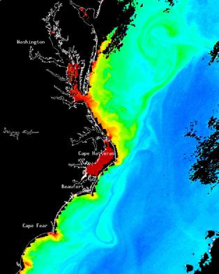
SeaWiFS chlorophyll image of waters off the US East Coast - September 30, 1997 (Image collected at the NASA GSFC Satellite Receiving Station and provided by the SeaWiFS Project, NASA Goddard Space Flight Center, Greenbelt, MB, USA).
How to obtain SeaWiFS data from the GSFC DAAC
Find the DAAC on the World Wide Web at the URL http://daac.gsfc.nasa.gov.
Look for SeaWiFS Data, Visual Search, or Ocean Color. All of these entry points will lead to the SeaWiFS Data Browser, organized according to data levels (1A, 2, and 3). After choosing the appropriate level, enter spatial and temporal search criteria and then begin examining the displayed browse files and selecting files to order.
Once the order is complete, information required for completion of the order will be obtained, and the order is then submitted.
For data orders that will be transferred by FTP, the response time is generally less than 72 hours. Tape orders are processed in less than 30 days, in an average of three working days for a 5 gigabyte (one tape) order, and subsequently mailed. Order processing times will vary with request load and order volume, with requests being processed in "first come, first served" order.
Additional assistance can be obtained from the OCDST or the Goddard DAAC Helpdesk.