
|
|
|
NASA has recently funded Mary-Elena Carr and Marjy Friedrichs of Jet Propulsion Laboratory, (in collaboration with Janet Campbell, University of New Hampshire and Dick Barber, Duke University, NC) to coordinate a comparison of models that estimate marine primary production from satellite measurements of ocean colour (PP models). For this project, the team is looking for inputs from people who have developed, modified, or are running a PP model. The outcome of the project promises to determine how the model compares with others given identical input fields, understand how and why it differs, and identify its strengths as well as the regions where it may give anomalous results. The project team is also keen to hear from people who do not want to participate with a model, but would like to be kept apprised of the results of the model comparison (which will be accessible via the Web). For more details write to Mary-Elena Carr.
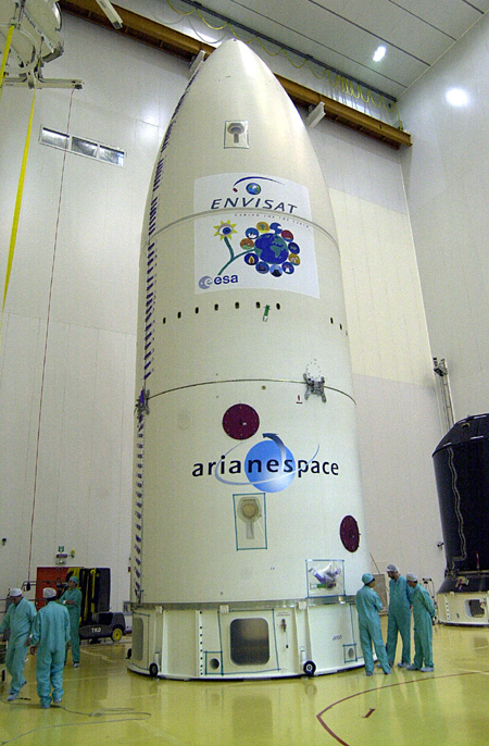 The launch of European Space Agency's new earth observing satellite, ENVISAT, carrying the MERIS ocean colour sensor, has been rescheduled for the end November 2001. The first phase of the ENVISAT launch campaign was successfully concluded in mid July 2001 at the Guyana Space Centre in Kourou (South America). The second phase of the launch campaign will start at the end of September (two months before confirmed launch date). In this phase, the flight batteries and the solar array will be installed, and the satellite propulsion tanks will be filled with hydrazine. Finally, the satellite will be installed on top of the Ariane 5 launcher.
 The IOCCG will be sponsoring Dr. Shailesh Nayak of the Space Applications Centre, ISRO, Ahmedabad, India to lecture on ocean-colour remote sensing at the Seameo/Biotrop training course entitled GIS and Remote Sensing in Coastal Zones. The course will take place in Bogor, Indonesia from October 23 to November 3, 2001 and will introduce students to remote sensing and GIS techniques as a tool for coastal zone applications and coastal zone management. The course will also discuss the methodology for collecting field data necessary to validate satellite data and investigate techniques for identification and mapping of coastal ecosystems and resources.
|
 The IOCCG will also be sponsoring several young Russian student to attend the first international conference on Current Problems in Optics of Natural Waters to be held in St. Petersburg, Russia, 25-29 September, 2001. The conference will consist of a plenary session with a number of distinguished invited speakers, as well as oral and poster sessions. Topics include: fundamental problems of radiative transfer theory, optical properties of natural waters, light propagation in water media and optics of sea surface and maritime atmosphere.
 NASA has posted a draft RFP (Request For Proposal) for the new Landsat Data Continuity Mission (LDCM), for comment. The performance goals include two new spectral bands relative to the Landsat 7 ETM+ (Enhanced Thematic Mapper-Plus): a band centered at 443 nm for coastal zone observations and a band centered at 1375 nm for cirrus cloud detection. Although LDCM is primarily designed for terrestrial remote sensing and does not have all the capability required for ocean colour remote sensing of coastal waters, (see IOCCG Reports Numbers 2 and 3), the addition of a spectral band centered at 443 nm (i.e. chlorophyll-a absorption maximum) will make LDCM data much more useful to coastal oceanographers than Landsat 7 ETM+ data (the LDCM also has the traditional Landsat TM/ETM+ blue, green, and red bands which would complement a new 443 band). LDCM also has a higher spatial resolution than any current or near-future ocean colour sensor. Thus, the IOCCG strongly supports the addition of the 443 nm band on LDCM.
The LDCM is an effort by NASA and the USGS (United States Geological Survey) to continue supplying the stream of multispectral data that the Landsat program has been providing for the past 25 years.
NASA has posted a draft RFP (Request For Proposal) for the new Landsat Data Continuity Mission (LDCM), for comment. The performance goals include two new spectral bands relative to the Landsat 7 ETM+ (Enhanced Thematic Mapper-Plus): a band centered at 443 nm for coastal zone observations and a band centered at 1375 nm for cirrus cloud detection. Although LDCM is primarily designed for terrestrial remote sensing and does not have all the capability required for ocean colour remote sensing of coastal waters, (see IOCCG Reports Numbers 2 and 3), the addition of a spectral band centered at 443 nm (i.e. chlorophyll-a absorption maximum) will make LDCM data much more useful to coastal oceanographers than Landsat 7 ETM+ data (the LDCM also has the traditional Landsat TM/ETM+ blue, green, and red bands which would complement a new 443 band). LDCM also has a higher spatial resolution than any current or near-future ocean colour sensor. Thus, the IOCCG strongly supports the addition of the 443 nm band on LDCM.
The LDCM is an effort by NASA and the USGS (United States Geological Survey) to continue supplying the stream of multispectral data that the Landsat program has been providing for the past 25 years.
New HRPT Stations  According to the latest news from the Ocean Color Data Support Team (OCDST), data from two new HRPT stations is now available. The stations are HROT (Rota, Spain) and HMSC (Matera, Italy). A total of 84 SeaWiFS HRPT stations have supplied 1 km resolution data, and it is available to SeaWiFS Authorized Research Users through the Goddard Earth Sciences Data and Information Services Center /Distributed Active Archive Center. (A note for potential users of this data: Not all HRPT station data at the GES DISC/DAAC is continuous in time, as redundant data from stations located in close proximity is not archived. For more information, contact the OCDST.
 Dr. Rangnath Navalgund has taken up a new position as Director of the National Remote Sensing Agency, (NRSA) Hyderabad, India. NRSA is an autonomous unit under the Department of Space, government of India. Its activities involve satellite data reception, aerial data acquisition, data processing, data dissemination and all remote sensing application-related activities. The Indian Institute of Remote Sensing, Dehradun, India is also a part of the NRSA. Previously, Dr Navalgund was with the Space Applications Centre, ISRO, Ahmedabad, India.
Two new employment opportunities are available at the University of South Florida (St. Petersburg Campus), USA. See our Employment Page for details.
|
|
Material for possible inclusion in the IOCCG Newsletter should be submitted to the Project Scientist. If you would like to be placed on the IOCCG News mailing list, and receive a brief summary of the latest news by e-mail (approximately once every 2 months), please send an e-mail with 'subscribe' in the subject line to subscribe@ioccg.org.To unsubscribe from the IOCCG News mailing list please send a message with 'unsubscribe' in the subject line to unsubscribe@ioccg.org.
|
|
|
|
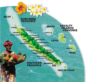 The Perth Regional Office of the IOC (Intergovernmental Oceanographic Commission) will be sponsoring a short Workshop on Remote Sensing Resources for Marine Management, at Institut de Recherche pour le Developpement (IRD) in Noumea, New Caledonia, September 25-27, 2001. The Workshop, organized by Associate Professor Mervyn Lynch of the IOCCG, aims to build regional capacity in ocean remote sensing, with an emphasis on ocean colour as well as regional applications of remotely-sensed data. Ten delegates from various nations in the South Pacific have been recommended by SOPAC (South Pacific Applied Geoscience Commission) to attend the course. During the 3-day course, delegates will be given an introduction to marine remote sensing and satellite data processing and will also participate in information and planning sessions to help identify regional management programs that could benefit from the use of remotely-sensed products. The IOCCG is sponsoring Dr. Robert Frouin of Scripps to lecture at this workshop, and the IOC Perth Regional Office is sponsoring four other Australian lecturers (including Prof Lynch). IRD Noumea is providing the venue and local organisational support for the Workshop.