
|
|
|
The Joint Research Centre (JRC) of the European Commission recently conducted a very successful ocean-colour training course entitled "Methods and Applications of Ocean Colour Remote Sensing in Coastal and Regional Seas", which took place in Ispra, Italy from 3-14 October 2005. Students were drawn primarily from new EU member states and Candidate Countries (PECO countries). The IOCCG sponsored two students from other countries (United Arab Emirates and China), as well as one lecturer. In addition, the Baltic Sea Regional Project (BSRP), whose overall aim is to combat the environmental degradation of the Baltic Sea, supported three students from the European Union and Russia. During the course, students covered important topics in the field of satellite oceanography and optical sensors through a number of key lectures (atmospheric processes, water optics, ocean-colour algorithms, pigments and primary production modelling, applications of ocean-colour data in coastal waters). Students also received hands-on training on various image processing software packages (SeaDAS, Bilko, Matlab) through a number of practical sessions. For a full report on the training course, please consult JRC's ECOMAR website.
The Korean Ocean Research and Development Institute (KORDI) will be hosting the eleventh IOCCG Committee meeting, which will take place in Busan, South Korea from 11-13 January 2006. At the meeting, the Committee will review the progress of the seven active IOCCG working groups, as well as the status of the associated reports. Proposals for new working groups will be discussed (two new proposals received) and a number of new capacity building initiatives will be addressed. Representatives from each of the major Space Agencies will also brief the Committee on important ocean-colour related activities. A draft agenda is now available on the IOCCG website.
Both instruments are functioning according to specifications and are projected to continue working well for another five years. Calibration and validation of both sensors is continuing on an ongoing basis and new processing algorithms and products are being developed. MERIS is being used operationally for phytoplankton monitoring in a number of regions: for example, the detection of Harmful Algae Blooms (HAB) carried out by the Nansen Environmental and Remote Sensing Center in Norwegian coastal waters, and routine determination of coastal water quality as part of the European Union's Framework Water Directive.
Australian researchers also demonstrated that MERIS was ideally suited to detect coral bleaching down to a depth of ten metres, potentially monitoring impacted coral on a global scale, twice a week. 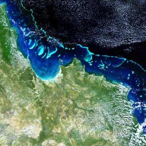 Coral bleaching occurs when the symbiotic algae of living coral polyps are expelled. It is linked to higher sea temperatures and may be one of the first tangible environmental effects of global warming. Theoretical studies indicated that for each complete 300-metre pixel of coral under one metre of water it is possible to detect a 2% bleaching of live coral. Australian scientists plan to progress the research to perform MERIS monitoring of bleaching events up to the scale of the whole Great Barrier Reef. The main area of concern at the conference was the issue of data continuity: any interruption in the (A)ATSR and MERIS data archives would be scientifically damaging. ESA's Ministerial Conference in December 2005 is due to consider a mission known as GMES-1 (Global Monitoring for Environment and Security) to ensure data continuity beyond Envisat.
|
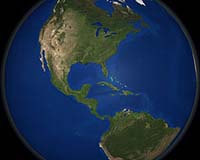 NASA recently shared the newest in its series of stunning Earth images, named the 'Blue Marble.' This new Earth imagery enhances the Blue Marble legacy by providing a detailed look at an entire year in the life of our planet. In 1972 the crew of Apollo 17 took the famous photograph of the Earth - the original 'Blue Marble', which inspired the later images of the Earth compiled from satellite data in 2000 and 2002. In October 2005, the creators of the Blue Marble released a new version of the spectacular image collection that provides a full year's worth of monthly observations with twice the level of detail as the original. The new collection is called the Blue Marble: Next Generation. This spectacular new Blue Marble is available free of charge to educators, scientists and the public. Users can download images of the entire globe, or just selected regions of interest. For further information please see NASA's Earth Observatory website.
The goal of NASA's Ocean Colour Time-Series Project is to produce a consistent, seamless time series of ocean colour products from 1978 to the present using CZCS, OCTS, SeaWiFS, and MODIS-Aqua data. This project is supported by the NASA REASoN (Research, Education, and Applications Solution Network)-CAN Programme and is headed by PI, Dr. Watson Gregg. SeaWiFS and MODIS algorithm development and data processing is conducted under separate funding by the Ocean Biology Processing Group, but this activity is allied with the Ocean Color Time-Series Project. The group has been working on the CZCS and OCTS (4-km data) with the aim of maintaining the CZCS and OCTS data sets at a level that is as consistent as possible with the current SeaWiFS and MODIS data sets, but also recognizing that there may be limitations to the data quality level due to coverage, sensor performance characteristics, in situ data availability, etc. The level-1 data will be made available via NASA's Ocean Color website, and SeaDAS will be updated to include the most recent processing code for each. The CZCS level-1 data set has been re-created to remove duplicate data using a set of data quality selection criteria. Level-1 and level-2 data can be browsed but not downloaded until the navigation issues have been resolved. Algorithm improvements (atmospheric and bio-optical) are being incorporated in the reprocessed 4-km global OCTS ocean-colour dataset (reprocessed by the SeaWiFS-SIMBIOS Project Office in collaboration with the Japanese space agency, formerly NASDA, in 2000). Level-1 data can be downloaded from the browser, and the latest version of SEADAS (4.8) has the ability to process the Level-1 OCTS GAC products to Level-2. By default, the algorithms employed for atmospheric correction are effectively identical to those used for SeaWiFS and MODIS/Aqua. Future updates will address calibration issues.
Borstad Associates Ltd., funded by the Department of Fisheries and Oceans, the Department of Environment and the Canadian Space Agency, have created a number of web-based ocean-colour visualization tools. These online tools are now publicly accessible at: http://www.borstad.com/grip.html One of the tools is a temporal profiler using SeaWiFS 8-day global composite data for the period spanning August 28 1997 through October 31 2004. The map currently spans -180 to 0 degrees West Longitude and 0 to 90 degrees North Latitude, however, the same data are available for the complete globe so it may be possible to set up the interface to allow for the broader map or other datasets. The developers have attempted to optimize the interfaces to be as fast as possible using any standard web browser. If you have any questions or suggestions regarding the profiler, or any of the other tools, please send an email to Gary Borstad (email: Gary@borstad.com). Any malfunctions can be referred to Peter Willis email: peterw@borstad.com .
A number of new workshops and conferences have been added to the IOCCG website including an international workshop on Coastal Oceanography and Ocean Optics to be held at Wimereux, France during the week 22-25 November 2005. The workshop will focus on bio-optical properties of coastal waters (specifically the Black Sea and the English Channel), in situ and remote measurements of biological, geochemical and optical parameters, and radiative transfer in the ocean-atmosphere system and atmospheric corrections. Please consult the Workshops & Conferences section of the IOCCG websitefor further details.
Several new oceanographic job opportunities have been posted on the IOCCG Empolyment Opportunities webpage. |
|
|
Material for possible inclusion in the IOCCG Newsletter should be submitted to the Project Scientist. Subscription to the IOCCG Mailing List.
|
|
|

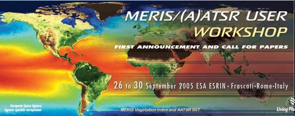 More than 220 European and world scientists attended the joint MERIS and (A)ATSR workshop organised by the European Space Agency. The workshop took place at ESRIN, Frascati, Italy from 26-30 September 2005 and provided scientists and data users with the opportunity to present first-hand and up-to-date results from their on-going research activities including discussions on scientific applications, data quality, development of new algorithms and data products. Of specific interest was the synergistic use of the data from these two instruments for operational applications, primarily in the marine environment and the coastal zones, but also for applications over land and the atmosphere. Both instruments produce visible-light images of the Earth. MERIS is optimised for the observation of ocean colour while AATSR's main task is to maintain a long-term record of sea surface temperature (SST).