|
|
|
The first meeting of the IOCCG working group addressing Level 1 Requirements for Ocean-Colour Remote Sensing was held in Washington, D.C. from 20-21 April 2010. The group is chaired by Chuck McClain, Gerhard Meister and Paula Bontempi of NASA. The goal of the working group is to develop a consensus for the minimum requirements for ocean-colour sensors that meet a broad range of user needs, and to identify options to sustain a long-term, global, climate research quality ocean-colour dataset. Representatives from NASA, ESA, JAXA, CNES and NOAA took part in the meeting and discussed the science traceability matrix (STM) in detail, which will provide the structure upon which the report of the working group will be based. An outline for the report was drafted, identifying the lead authors for each of the seven chapters (see the Minutes of the meeting). The next working group meeting is tentatively scheduled for November 2010 (in Europe). Presentations from the April meeting in Washington can be viewed at:
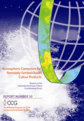
The IOCCG working group on Comparison of Atmospheric Correction Algorithms has been testing the performance of a number of operational atmospheric correction algorithms (i.e. MERIS, POLDER, OCTS/GLI, MODIS-Aqua and SeaWiFS) for various cases such as weakly- or strongly-absorbing aerosols. Their findings have been published in IOCCG Report 10 entitled Atmospheric Correction for Remotely-Sensed Ocean-Colour Products, edited by Menghua Wang (NOAA). The report also provides an overview of other approaches developed in recent years for regional applications, in particular, for dealing with turbid coastal waters. In addition, comparison results for deriving aerosol optical thickness data are presented. The most important conclusion from the report was the good performance of all the algorithms in Case-1 waters (the bulk of the global oceans) with the assumption of realistic maritime aerosol models. Specific improvements were recommended for areas near the coast with high concentrations of dissolved organic matter and/or suspended sediments, and areas influenced by windblown dust or urban pollution. The report is currently being printed by NOAA, and will be mailed, via surface mail, to all subscribers on the IOCCG mailing list within the next few months.
It was recently brought to our attention that small number of copies of IOCCG Report 9 (Partition of the Ocean into Ecological Provinces) had been incorrectly bound (duplicate/missing pages). For this reason, the mailing of the reports from the Joint Research Centre (JRC), Italy, was put on hold until all the incorrectly-bound copies had been removed. The mailing process has since resumed, so please be patient if you have not yet received a copy of Report 9. If you inadvertently received an incorrectly-bound copy, please contact the IOCCG Project Office (vstuart-at-ioccg.org ) for a replacement copy.
A new project entitled FARO (Fisheries Applications of Remotely-sensed Ocean-colour) has been established to promote the global dissemination of ocean-colour data for use in fisheries research and other societal benefit areas. The project, funded primarily by the Canadian Space Agency, will continue to develop the successful SAFARI initiative (Societal Applications in Fisheries and Aquaculture using Remotely-Sensed Imagery) and will also support the related ChloroGIN project (Chlorophyll Global Integrated Network) founded by POGO. ChloroGIN is an international network to assess the state of marine, coastal and inland-water ecosystems for the benefit of society, promoting in-water observations in synergy with ocean-colour remote sensing and other related satellite observations. Both the SAFARI and ChloroGIN projects are supported by IOCCG and POGO (amongst other organisations) and are contributing towards the development of a Global Earth Observation System of Systems (GEOSS) under GEO (Group on Earth Observations).
The goal of FARO is to expand upon, and merge, the frameworks created by the SAFARI and ChloroGIN programmes, which have laid the foundation for more effective management strategies on both national and international levels. FARO aims to integrate and foster the widespread usage of ocean-colour data into sustainable fisheries and related practices. This core goal will bring together experts from SAFARI and ChloroGIN at the international level to help understand ecosystem structure and function in the ocean, and to implement ecosystem-based management for sustainable fisheries on an international scale. FARO also aims to continue the capacity building initiatives within Canada, which were initiated under SAFARI, and to extend this outreach to developing nations via ChloroGIN. A website for FARO is currently under development.
 The Envisat mission was launched by ESA in March 2002 for a nominal 5-year lifetime, but careful management of the satellite orbital manoeuvres has allowed Envisat to operate for an additional 3.5 years, i.e. until the end of 2010. Recently, ESA Member States voted unanimously to extend the Envisat mission through to 2013, in recognition of the success of the mission in terms of the large number of scientific and operational users, and the good technical status of the satellite after seven years of operations. Many established services rely on access to near-real-time (NRT) Envisat data. Also, scientists need a long time-series of data to identify and analyse long-term climatic trends and changes (such as greenhouse gas concentrations, sea surface temperature). Consideration of all possible options led to the selection of a new orbit, called the "Envisat extension orbit". This orbit will allow the mission to be operational for an additional 3 years, using a minimum amount of hydrazine, and will ensure the continuity of the maximum number of Envisat applications, with the exception of ASAR Interferometry which will be degraded. The new Envisat orbit will be implemented at the end of October 2010, through an altitude decrease of 17.4 km, which will be reached through different orbital manoeuvres starting on 22 October 2010. Consequently, the Envisat data flow will be suspended during the period 22 October to 1st November 2010. The data flow will resume on 2nd November 2010. For more information on the implementation of the Envisat orbit extension starting in October 2010, see http://earth.esa.int/object/index.cfm?fobjectid=6999
Several new positions have been added to the Employment Opportunities section of the IOCCG website, including a Science Officer at ICSU (Paris, France), PhD position in Atmospheric Correction at the Laboratory of Oceanology and Geoscience (Wimereux, France), a Research Chair in numerical modeling of Arctic marine ecosystems at Universit� Laval (Quebec, Canada) and a Research Associate in the Optical Remote Sensing Laboratory, City College of City University of New York (CCNY), USA. |
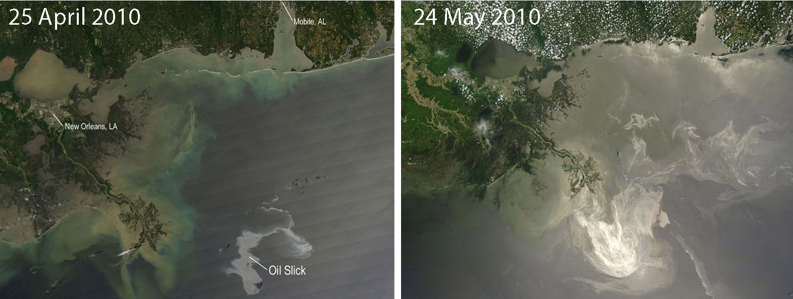 Image Credit: NASA/MODIS Rapid Response Team (Click on image for larger view) MODIS instruments aboard NASA's Terra and Aqua satellites are capturing images of the disastrous oil spill in the Gulf of Mexico, which began on 20 April 2010. The images above were obtained from NASA�s Oil Spill website. MODIS-Aqua captured the silvery oil slick on the left on 25 April 2010. The oil slick is apparent in these images because it is occurring under conditions of sun glint � a phenomenon used by Chuanmin Hu et al. in their 2009 paper (published in Geophys. Res. Lett.) to detect natural oil slicks in the Gulf of Mexico. Some of the high contrast between oil slicks and the background water is not due to the difference in optical properties of the oil film and the water (as evidenced by the lack of contrast in other glint-free images), but due to the oil-modulation of the surface capillary waves � the same principle for SAR measurements. The image on the right, showing the much larger oil spill, was captured by MODIS-Terra on 24 May 2010.
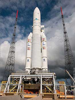
The Ariane 5 mission, carrying the South Korean COMS multi-purpose spacecraft and the Arabsat-5A, has been postponed because of a launcher subsystem anomaly that occurred during the final countdown at the Guiana Space Center (ESA's spaceport in French Guiana). The heavy-lift Ariane 5 and its two payloads remain in a safe standby mode on the launch pad. A new launch date will be announced as soon as possible. The COMS satellite will carry three payloads including the Geostationary Ocean Color Imager (GOCI), which is an 8-band imager that will provide hourly coverage of a 2500 km2 area at 500 m resolution. GOCI will be the first ocean-colour instrument in geostationary orbit. GOCI will detect, monitor, and predict short-term and regional oceanic phenomena such as harmful algal blooms, red tides, plumes and transport of suspended sediment, Asian dust, and fishing ground information. The advantages of a geostationary orbit are numerous e.g. continuous observation of the scene of interest, with images provided every hour, maximizing the chance of clear observations over the entire scene even in the cloudy season, and the possibility of short term (daily) operational monitoring. The Korea Ocean Research & Development Institute (KORDI) has developed the GOCI Data Processing System (GDPS) which will produce ocean data such as chlorophyll concentration, TSS, CDOM and red-tide index. To retrieve water-leaving radiance more precisely, atmospheric- and BRDF-correction algorithms have been optimized for the GOCI coverage area and the COMS satellite orbit characteristics, and have been implemented into the GDPS. GOCI Level 2 data will be provided with 8 VNIR band images with 4967 x 5185 pixel resolution over the GOCI coverage area. The Korea Ocean Satellite Center (KOSC) has been established by KORDI for the acquisition, processing, storage and distribution of standard products generated from the GOCI data.
 Archbishop Desmond Tutu signing the agreement for the creation of the Nansen-Tutu Centre for Marine Environment Studies in Cape Town. Photo credit: Katherine Traut, UCT News. (Click on image for larger view) South Africa's new OceanSAfrica programme is an African operational oceanography initiative that draws together key marine science institutes under four activities: in situ observations, marine remote sensing, coupled ocean modelling, and data management/dissemination. The programme has recently received a major boost with the launch of the Nansen-Tutu Centre for Marine Environmental Research at the University of Cape Town, an international collaboration between UCT (South Africa); the African Centre for Climate and Earth System Studies ACCESS, hosted by the Council for Scientific and Industrial Research (South Africa); the Nansen Environmental & Remote Sensing Centre (Norway), the Institute of Marine Research (Norway), the University of Bergen (Norway), and Princeton University (USA). The Centre will undertake joint research and development activities, with a strong focus on exchange and capacity development. Primary aims are the development and implementation of regional operational oceanography systems, concentrating on coupled models and data integration. The South African Marine Remote Sensing Unit, as part of these initiatives, is in the process of rebuilding its Earth observation processing capability using the new Sun cluster based at the CHPC. The new cluster, rated at 27 TeraFLOPS, is amongst the fastest 500 supercomputers in the world and is a national research facility funded by the South African Department of Science and Technology. The new capability is expected to be in place by the end of 2010, and should provide significantly greater access to marine Earth observation data for all African users.
Several new references have been added to the IOCCG Recent References list, including a paper by Lucile Dufor�t-Gaurier et al. (2010) published in Deep-Sea Research, entitled "Estimates of particulate organic carbon over the euphotic depth from in situ measurements. Application to satellite data over the global ocean." Knowledge of the oceanic particulate organic carbon (POC) pool and its spatio-temporal variability is important to understand the oceanic carbon cycle. Until now, POC estimates from space have been restricted to the surface layer.
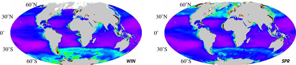
In this paper, the authors developed an empirical algorithm to derive the POC content integrated over the euphotic layer, (POCZeu) from the near-surface POC concentration (POCsurf). The relationship follows a power-law distribution, POCZeu = A x POCBsurf with A and B dependant on the water type (stratified or well-mixed) and on the near-surface chlorophyll concentration. A global climatology of POCsurf and POCZeu was generated over the SeaWiFS archive (1998 - 2006) and it was found that the global patterns of POCsurf and POCZeu follow the major gyre systems and other large-scale circulation features. High surface and integrated POC values (~150 mg m-3 and 6000 mg m-2) were encountered at high latitudes, whereas low values (<50 mg m-3 and 2000 mg m-2) were observed in the subtropical gyres. The mean global values of POCsurf and POCZeu over the global ocean are 53 mg m-3 and 3742 mg m-2, respectively while the standing stocks of POC are 3.92 x 10¹⁴ and 1.19 x 10¹⁵ g over the first penetration and euphotic depth, respectively.
The Maritime Rapid Environmental Assessment Conference will take place in Italy (18 - 22 October 2010). The objective of the conference is to review the present state-of-the-art in quantifying, predicting, understanding and exploiting uncertainties within the operational oceanography context. For further details see the announcement. |
|
Material for possible inclusion in the IOCCG Newsletter should be submitted to the Project Scientist, Dr. Venetia Stuart
Subscription to the IOCCG Mailing List. Participants receive a brief summary of the IOCCG Newsletter by e-mail (quarterly), as well as hard copies of IOCCG Reports as, and when, they become available.
|
|
|
|