|
|
|
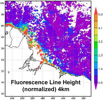
The GES DISC recently added current MODIS-Aqua data products at both 4 and 9-km spatial resolution (monthly temporal resolution) to the Ocean Color Radiometry Giovanni data portal. This update is an element of the NASA-funded Water Quality for Coastal and Inland Waters project (PI: Zhongping Lee; Co-PI's: James Acker and others) which is refining algorithms for several water quality-related data parameters, focusing on coastal regions and large lakes. This update is significant because:
A new data portal for water quality will be added to Giovanni shortly. In this portal, numerous evaluation data products acquired from the OBPG will be available, particularly absorption coefficients and backscattering coefficients from several models as well as Zhongping Lee's euphotic depth product.
The Aquarius/SAC-D satellite was successfully launched from the Vandenberg Air Force Base on 10 June 2011. NASA provided the primary instrument Aquarius, and launch services, while CONAE (Argentina’s space agency) supplied the SAC-D spacecraft and ground system. The SAC-D spacecraft also carries a suite of seven other instruments with various science objectives. The Aquarius instrument will gather global measurements of sea surface salinity, leading to a better understanding of ocean circulation, climate and the Earth's water cycle. Within a few months, Aquarius will collect as many sea surface salinity measurements as the entire 125-year historical record from ships and buoys. Once in orbit, the spacecraft will go through a checkout period before it starts its three-year mission.
Thermal vacuum testing for the NPOESS Preparatory Project (NPP) satellite has been completed to advance the spacecraft closer to a planned launch on 25 October 2011. The polar-orbiting NPP satellite will continue providing long-term weather forecasting and environmental monitoring, and will carry the Visible Infrared Imaging Radiometer Suite (VIIRS) along with a suite of other advanced-technology remote sensing instruments. VIIRS is a multi-disciplinary sensor providing data for measurement of cloud and aerosol properties, ocean colour, sea and land surface temperature, ice motion and temperature, fires, and Earth's albedo. VIIRS spectral coverage will allow for data products similar to those from SeaWiFS as well as SST measurements. The restructured Joint Polar Satellite System (JPSS) will provide operational continuity of satellite-based observations and products for NOAA Polar-orbiting Operational Environmental Satellites as well as the NPP mission.
The Korea Ocean Satellite Centre (KOSC) has been disseminating data from the Geostationary Ocean Color Imager (GOCI) since 20 April 2011. Currently GOCI RGB and Level-1B full resolution images are being produced. Data can be downloaded free of charge from the KOSC home page once you have registered. To register, click the “Join” button on the KOSC home page and enter your personal details as well as a short proposal (Introduction) outlining your planned research using GOCI data. At present, GOCI data is available for three time periods per day (11h, 12h, 13h local time) and will be extended to the full service of 8 times per day in due course. The GOCI Data Processing System (GDPS) is not yet available but the software can nevertheless be downloaded and used as viewing software. KORDI would very much appreciate receiving your feedback on their data service (data download speed, ease of navigation etc.) Please send your comments and suggestions to: Mr. Hee-Jeong Han (han77@kordi.re.kr)
|
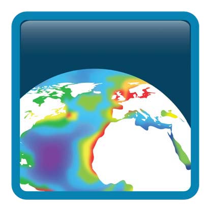
The second Climate Change Initiative (CCI) co-location workshop will take place on 12-14 October 2011 at ESA/ESRIN (Frascati, Italy). The CCI initiative was developed by ESA to provide a comprehensive and timely response to the set of requirements for stable, long-term satellite-based products for climate (called Essential Climate Variables, or ECVs). The ocean colour CCI (OC-CCI) project is focusing on the ocean colour ECV encompassing radiance, derived chlorophyll and inherent optical properties, and will utilise data from MERIS, SeaWiFS, MODIS and CZCS archives. Over the next few years the OC-CCI project will develop and validate algorithms to meet the Global Climate Observing System (GCOS) requirements for global satellite data products from multi-sensor data archives, and will produce and validate a consistent time series of multi-sensor global satellite data products for climate research and modelling.
The 3rd CoastColour User Consultation Meeting (UCM) will take place in Lisbon, Portugal on 19 - 20 October, 2011. This will be the last UCM during the 2-year duration of ESA's CoastColour project. The focus of the meeting will be on the results of the project activities, specifically, the results of the Round Robin exercise, algorithm development, and the validation and usage of CoastColour products. Discussions will also be held on the continuation of a forum for the coastal remote sensing community to facilitate international communication and collaboration.
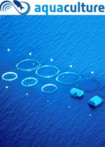
A workshop took place in Oslo from 31 March to 1 April 2011, to bring together users and experts in the aquaculture sector to define a set of user requirements which will be used as basis for ESA's future Aquaculture Project. The project aims to develop, demonstrate and validate information services in support of aquaculture management, exploiting state-of-the-art remote sensing, modelling and data integration methods. Relevant Earth observation technologies and techniques will be channelled into one activity dedicated to aquaculture, to take an important step towards operational services for e.g. locating optimal sites for aquaculture; monitoring production conditions and threats (algal blooms, jellyfish) and monitoring environmental impacts. All organizations (private and public) from ESA Member States will be invited to submit proposals to carry out the work. The project will run from October 2011 to October 2013.
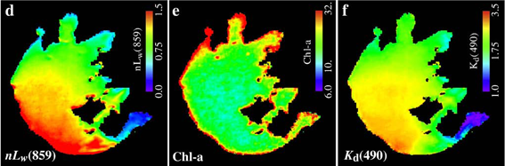
Several new references have been added to the IOCCG Recent References list, two of which are highlighted here. The first is a paper by Menghua Wang et al. (2011) entitled Water property monitoring and assessment for China's inland Lake Taihu from MODIS-Aqua measurements, which recently appeared in Remote Sensing of Environment. The authors used MODIS-Aqua measurements from 2002 - 2008 to characterize water properties of Lake Taihu in China, and to study the 2007 blue-green algae bloom in detail. Waters in Lake Taihu are consistently highly turbid all year round with frequent large seasonal algae blooms. An iterative SWIR-based atmospheric correction algorithm was developed to provide water-leaving radiance spectra data for this extremely turbid lake. Climatological water property maps, including normalized water-leaving radiance spectra nLw(λ), Chl-a concentration, and diffuse attenuation coefficient at 490 nm, Kd(490), were derived. This study demonstrates an important application for monitoring inland freshwater optical and biological properties as well as water quality using satellite ocean colour measurements.
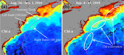
The second is a paper by Wei Shi and Menghua Wang (2011) entitled Satellite Observations of Asymmetrical Physical and Biological Responses to Hurricane Earl, which appeared in Geophysical Research Letters. The authors used a combined data set of MODIS-Aqua ocean colour and AMSR-E SST observations to investigate the physical and biological responses to Hurricane Earl in 2010, which threatened the U.S. New England region and made landfall in Nova Scotia, Canada. Hurricane Earl induced broad drops in SST and elevated Chl-a concentrations along its track, but of particular note was the observation that the ocean’s physical and biological responses were notably asymmetrical i.e., right-biased. In the ranges within 100 km off the track, the SST dropped ~1.85°C and ~1.23°C on the right and left sides, respectively, and the ratios of Chl-a concentration before and after the passage of Hurricane Earl were 2.04 and 1.33 on the right and left, respectively. Temperature and salinity profiles of an Argo float on Earl’s track show that the ocean’s physical response occurred mostly within the mixed layer and thermocline in the upper 70 m water column.
|
|
Material for possible inclusion in the IOCCG Newsletter should be submitted to the Project Scientist, Dr. Venetia Stuart
Subscription to the IOCCG Mailing List. Participants receive a brief summary of the IOCCG Newsletter by e-mail (quarterly), as well as hard copies of IOCCG Reports as, and when, they become available.
|
|
|
|