|
|
|
The final minutes of the 9th IOCCG Committee (15-17 January 2004, Hyderabad, India) can now be viewed on the IOCCG website, under the Reports and Publications section .
The 20th congress of the International Society for Photogrammetry and Remote Sensing (ISPRS) will take place in July 2004, in Istanbul, Turkey. The IOCCG will be co-sponsoring a workshop (WS5) on "Ocean Colour; Techniques and Application", immediately preceeding the congress (12-13 July 2004). The workshop will be convened by Dr. Shailesh Nayak of ISRO, with contributions from Dr. Mark Dowell (JRC) who will lecture on in-water algorithms with special emphasis for coastal waters, and Dr. Nicholas Hoepffner (JRC) will talk on primary production with global and regional perspectives.
Ministers from 47 nations and the European Commission met last month in Tokyo for the fourth meeting of the ad hoc Group on Earth Observations (GEO). GEO is a high level intergovernmental working group, tasked with developing a plan for a comprehensive, co-ordinated global Earth Observation network. GEO was established during the Earth Observation Summit in Washington DC last year and was tasked to produce a 10-year implementation plan for establishing an integrated Earth observation system, to be known as the Global Earth Observation System of Systems (GEOSS). At the GEO-4 summit, the draft implementation plan was approved and a final draft of the plan establishing GEOSS will be presented to ministers at the third Earth Observation Summit, slated for Brussels, Belgium, in February 2005. Five separate GEO Subgroups, dealing with the subjects of Architecture, Capacity Building, Data Utilization, User Requirements and International Cooperation, will help with the implementation. For further information on GEO see http://earthobservations.org/default.asp
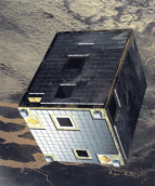
ESA's minature PROBA satellite, launched in 2001, is one of the most advanced small satellites ever flown in space. It measures just 60 x 60 x 80 cm, and its main instrument payload is the Compact High Resolution Imaging Spectrometer (CHRIS), which acquires images of the Earth's surface at a resolution of 18 metres. Last month around 40 researchers met at ESA's European Space Research Institute in Frascati, Italy to discuss the current and future uses of the instrument at a three-day workshop (Second CHRIS/PROBA Workshop, 28-30 April 2004). CHRIS was designed for Earth Observation over land surfaces, but a number of research teams are investigating its use to study inland or coastal waters. One of the proposals intends to use data from CHRIS to detect traces of potentially harmful phytoplankton in inland reservoirs.
 The 2004 ENVISAT Symposium will take place in Salzburg, Austria from 6 to 10 September 2004. The main objectives of the Symposium are to provide a forum for investigators to present results of on-going research project activities and to review and assess the development of applications and services. The Symposium is open to all interested parties, from scientists to operational users, and will cover both ENVISAT and ERS missions. Presentations are expected from ESA Principal Investigators, and scientists working in the framework of national investigations and projects. See the Envisat Symposium Website for further details.
At any given time, more than 30 civilian Earth-observation satellite sensors are monitoring the marine environment. Their operating frequencies range from the ultraviolet to the microwave and collectively their applications are relevant to all of the primary disciplines of oceanography. OEA Technologies has synthesized information on the marine applications, limitations and technical details of all of these satellites into four interactive tables, which are now available on the internet. The tables can be accessed at www.oeatech.com/eos.htm by clicking on any one of fourteen listed coastal applications. They can also be accessed by sensor type, as follows: (i) Land-optimized Multispectral Satellite Sensors, (ii) Marine Multispectral and IR Sensors, (iii) Altimeters and Synthetic Aperture Radars, and (iv) Passive Microwave Sensors. Each table provides a link to the satellite's home Web site and identifies the sensor's marine applications, defines acronyms, explains satellite technical terms, etc. The site also provides an online remote sensing tutorial through a link to the Canada Centre for Remote Sensing. Comments regarding errors, omissions or updates to the tables, or suggestions for additional information that would be useful to the marine community, can be sent directly to OEA Technologies at info@oeatech.com .
|
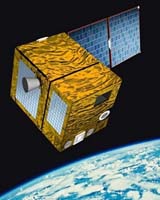 The French Space Agency, CNES, is preparing to launch a new generation of microsatellites, the Myriade series, developed to offer scientists a cheaper access to space. The first microsatellite, Demeter, will be launched on 29 June 2004, and will study electromagnetic perturbations created by earthquakes. The second satellite, PARASOL, should be launched in October 2004 with an Ariane 5, as a piggyback to the military observation satellite Helios 2. PARASOL will carry an instrument very similar to the POLDER-II ocean-colour sensor. The PARASOL mission will focus on characterisation of clouds and aerosols, but CNES is also considering using it for ocean-colour use, as a follow-on to POLDER-II. With the Myriade series, CNES is offering faster and cheaper access to space. The Myriade bus is small (60 cm length) and weighs only 120 kg. These are two requirements to be accepted as piggyback payload onboard big launchers.

The processing of the new SeaWiFS MLAC product (Merged Local Area Coverage) has been completed. This is an improved high resolution SeaWiFS data product, derived from the 1-km SeaWiFS HRPT and recorded LAC data, that reduces geographic overlap from multiple receiving stations. The data quality of the final product has been significantly improved, with a substantial reduction in data volume. Both Level-1 and Level-2 data will be available for this new data set, along with the same products derived from the GAC (4-km) data. The MLAC generation will be kept current up to 15 days from real-time.
MODIS-Aqua Processing
The first official processing of the MODIS/AQUA data set within the Ocean Color Discipline Processing Group (OCDPG) at NASA/GSFC has begun. The modifications have greatly improved the consistency between SeaWiFS and MODIS/Aqua derived products, and the complete Aqua mission should be reprocessed within about two weeks.
The latest Science Focus! article, entitled "Oh Black Water, Keep On Rollin" takes a look at a number of "black water" rivers from around the world. These rivers contain large amounts of coloured dissolved organic matter (CDOM). There are several spectacular images, including one of the Rio de la Plata estuary in Argentina, captured by the MODIS sensor, and one of the Gulf of Mexico with the Suwannee River, captured by SeaWiFS. The full article can be viewed at http://daac.gsfc.nasa.gov/oceancolor/black_water.shtml
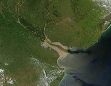 MODIS image of the Rio de la Plata estuary.
The final report from the panel assessing the status of NASA's ocean colour remote sensing capabilities, with a focus on the performance of Terra and Aqua MODIS for ocean colour data, has been posted in the documents section of NASA's Ocean Color Web page. The report is entitled "MODIS Calibration Review Panel - Final Report". The panel report contains important information on the background and rationale as to why the panel was convened, an evaluation of SeaWiFS and MODIS data, and potential implications for future ocean-colour sensors.
 Presentations from the Ocean Colour Research Team meeting held in Washington DC last month (14-16 April 2004) are available on NASA's Ocean Color Web site. At the meeting, a number of working groups were formed to discuss specific measurements, data products and algorithm selection. Discussion of the various products submitted for consideration by the Data Product Working Group can take place on the Ocean Color Forum. A working group on Calibration and Validation was also formed, and is open to the community.
A number of new positions in ocean colour have been added to the IOCCG Employment Opportunities section, including a post-graduate position in atmosphere/ocean remote sensing at the University of California and a Remote Sensing/GIS position in Vienna at the UN. See also the Training and Education section, for a postgraduate fellowship for women scientists in sub-Saharan Africa.
Several new references have been added to the Recent Ocean-Colour References page of the IOCCG website. If you would like to see your references added to the IOCCG bibliography, please submit them to the Project Officer.
|
|
Material for possible inclusion in the IOCCG Newsletter should be submitted to the Project Scientist. Subscription to the IOCCG Mailing List.Participants receive a brief summary of the IOCCG Newsletter by e-mail (bi-monthly), as well as hard copies of IOCCG Reports as they become available. Subscribe to mailing list (Please include your name, address and email address in the body of the message.) Unsubscribe from mailing list
|
|
|
|