|
|
|
Several IOCCG working groups have been active over the past few months, conducting working group meetings, planning future meetings and outlining new IOCCG reports. Details of these activities are given below.
A new joint working group on Harmful Algal Blooms and Ocean Colour was recently established by the IOCCG and GEOHAB (Global Ecology and Oceanography of Harmful Algal Blooms) to help consolidate information regarding the suitability of ocean-colour techniques for harmful algal bloom (HAB) application in different ecosystems. Ocean-colour radiometry offers considerable potential for the observation of a variety of HAB types. Realising this potential requires: a synthesis of bloom- and ecosystem-types amenable to remote sensing observation; a review of the benefits and limitations of ocean colour approaches in these typically optically-complex coastal ecosystems; and the development of appropriate phytoplankton ecological frameworks to realise the full value of ocean colour products. The combined IOCCG/GEOHAB Working Group aims to: summarise the state of knowledge concerning ocean colour-based HAB methods; examine and demonstrate the suitability of various ocean-colour approaches through comparative bloom case studies from different ecosystems; and outline appropriate frameworks within which to further develop ocean colour-based HAB observation. A successful WG meeting took place in Cape Town, South Africa from 24-26 August 2010. A review of the meeting, plus an outline of the proposed IOCCG report will be available shortly on the HAB working group website.
The Ocean Colour Radiometry-Virtual Constellation (OCR-VC) will hold an ocean-colour cal/val session at JRC (Ispra, Italy) on 21 Oct 2010, following the CEOS WGCV-IVOS workshop (18-20 October 2010). The OCR-VC cal/val session will be an essential opportunity for reviewing current cal/val best-practices and making gap analysis to meet needs of the newly formulated "Integrated Network for Sensor InTercomparison and Uncertainty Assessment for OCR" (INSITU-OCR). Presentations from various agencies (JRC, KORDI, ESA, EUMETSAT, CNES, JAXA, NASA, CSIRO) as well as from IOCCG and Brockman Consult representatives, will highlight studies using data from buoys, ships and towers as well as in-situ protocols, invariant standards (offshore, high clouds, moon), sun glint, cross-calibration, FOV/detector dependencies, and on-board calibration.
The IOCCG working group assessing Level 1 Requirements for Ocean-Colour Remote Sensing will be meeting in London, UK on 9-10 November 2010. At the first meeting of this working group, held in Washington, DC last April, members outlined the report and assigned lead authors for each chapter. Since then, the discussions on the contents of each chapter and the transitions between chapters have continued during regular teleconferences every two weeks. The purpose of the London workshop is to pull the chapters together into an initial draft that can be submitted to the IOCCG prior to their February 2011 IOCCG meeting.
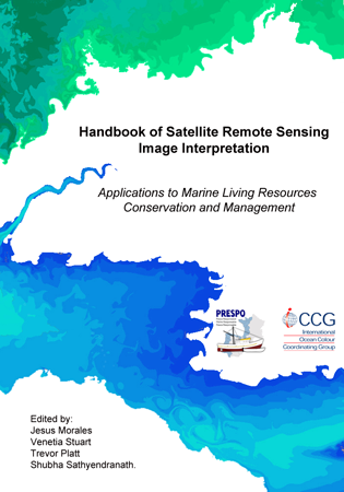
The IOCCG, in conjunction with the EU PRESPO Project for sustainable development of the artisanal fisheries in the Atlantic area (within the INTERREG IVB Programme) has prepared a handbook of satellite remote sensing image interpretation, with a focus on applications for marine living resources conservation and management. This handbook is a web-based educational/training document oriented towards the interpretation of satellite images derived from data freely available (for the most part) from various space agency archives. The current knowledge in this field is represented through a number of case studies which guide the end-users on how to download and interpret the satellite-derived image data. The case studies cover a range of applications including fisheries and aquaculture, phytoplankton and macroalgae, marine ecosystem characterization and air/water quality. The studies utilize data from a number of ocean-colour sensors, as well as other satellite instruments measuring variables such as ozone, SST, rainfall and wind speed. A "beta version" of the handbook is available for download from Training & Education section of the IOCCG website (www.ioccg.org/training_ioccg.html), and will also be available on the PRESPO website shortly. Additional case studies might be added at a later stage. The final version should be ready by early 2011. A limited number of CDs will be issued by the PRESPO project for end-users with limited Internet connections. In addition, the FARO Project (Fisheries Applications of Remotely-sensed Ocean-colour), sponsored by the Canadian Space Agency, intends to distribute some or all of the contributions - details to be decided.
A new scientific consortium called GIS COOC (a French acronym for "Groupement d�Int�r�t Scientifique � COlour of the OCean"), was recently formed to help understand the role of marine phytoplankton in the global carbon cycle as well as their interactions with climate change. The group will focus on the scientific interpretation and use of data obtained from current ocean-colour satellites and in situ sensors, and will also address issues related to future satellite sensors. The partners of the consortium are the Pierre et Marie Curie University (UPMC), the National Institute of Sciences of the Universe (INSU/CNRS), the Centre National d'Etudes Spatiales (CNES) and the ACRI-ST company. The consortium is born of a ~20 year collaboration between ACRI-ST and the Marine Optics and Remote Sensing Group of the Laboratoire d�Oc�anographie de Villefranche (LOV/UPMC - CNRS), a prominent research group in the field of ocean-colour remote sensing. Cooperation among the different partners of the consortium includes the sharing of scientific and technical expertise, mutual assistance in terms of human and technical resources, dissemination and application of results from joint studies, and planning of future remote sensing activities. In the long run, the consortium aims to become a production & archiving centre, and a data portal for future French and/or European ocean colour space and in situ missions dedicated to the study of ocean biogeochemistry and the role of the oceans in climate change. The scientific objectives of the GIS COOC include ocean colour algorithm research and development to estimate biogeochemical properties in the open ocean and coastal zones; the creation of biogeochemical data archives for the global ocean (Essential Climate Variables); and the continuation of key calibration and validation activities (e.g., through the use of data acquired by the permanent instrumented "BOUSSOLE mooring" in the Mediterranean). The chair of the GIS COOC Council is Professor Jean Charles Pomerol, President of UPMC. The director of the GIS is UPMC Professor Louis Legendre and the Chair of the Steering Committee is Dr. Constant Mazeran, a research engineer at the ACRI - ST company. For further details please see the official Press Release, or email info@gis-cooc.org. A web page and data portal will be available in 2011.
The continuity of satellite ocean colour data and associated climate research products from U.S. sensors is currently at risk because of the uncertainties surrounding the performance of the VIIRS sensor, soon to be launched on NPP. Therefore, U.S. agencies (NOAA, NASA, NSF, and ONR) have asked the National Academy of Sciences to convene a committee to assess lessons learned from the SeaWiFS/MODIS era, to guide planning for acquisition of future global ocean colour radiance data. This study aims to identify the ocean colour data needs for a broad range of end users, develop a consensus for the requirements, and outline options to meet these needs on a sustained basis. Temporal, radiometric, spectral, and geometric performance of future global ocean colour observing systems are being considered in the context of the full range of research and operational/application user needs. It will also perform a high-level gap analysis between the requirements and the current and planned sensors. The committee is chaired by Jim Yoder (former IOCCG Chair) and its membership includes the current IOCCG Chair David Antoine. The committee has held two meetings this year (April 20-22 and June 28-30) and will convene a third meeting in November 2-4, 2010 in Washington D.C. This third meeting will include a discussion of international data access and exchange, in particular between ESA and NASA/NOAA. The committee�s peer-reviewed report should be available by spring of 2011. For further information on the study, see the Studies in Progress section of the National Academies website.
Several new positions have been added to the Employment Opportunities section of the IOCCG website, including a PhD position in marine optics and remote sensing at the University of Technology (Sydney, Australia), a Researcher for the company Water Insight (Netherlands), an ocean colour scientist for the Climate Change Initiative (Plymouth Marine Laboratory, UK), a Postdoctoral Fellow position at Curtin University (Perth, Australia), Ph.D and M.Sc positions at University of Victoria and University of British Columbia (Canada), and a Researcher in Aquatic Optical Modelling and Monitoring Techniques at the Finnish Environment Institute (SYKE), Finland. |
ESA's CoastColour project aims to improve the use of MERIS data for applications in the coastal zones by developing, demonstrating and validating the latest advanced techniques for retrieving information on water constituents. During a preparatory User Consultation Meeting (Cork, 19-20 March 2009), general requirements were identified for the development and demonstration of the use of MERIS data for monitoring water constituents in Case 2 coastal waters. These requirements cover a range of applications, for example, coastal ecosystem research, early warning for aquaculture, sediment transport, water quality and pollution monitoring. A consolidated list of data products and services has been drawn up based on these requirements and will be delivered under the CoastColour project. The first CoastColour User Consultation Meeting will take Frascati, Italy 16-17 November, 2010 and is open to all current and potential CoastColour users, interested scientists and coastal managers. The object of the meeting is to discuss the progress of the project, present ocean-colour algorithms and products in the coastal zone and to provide updates on user activities, user requirements and expectations.
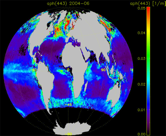 Global map of absorption by phytoplankton at 443nm from June 2004, derived from SeaWiFS radiances using the PML IOP model. Produced by Taka Hirata (PML, now at University of Hokkaido) ESA's new Climate Change Initiative (CCI) programme, aims to realize the full potential of the long-term global Earth Observation archives that ESA, together with its Member states, have established over the last thirty years, as a significant and timely contribution to the Essential Climate Variable (ECV) databases required by United Nations Framework Convention on Climate Change (UNFCCC). The Ocean Colour CCI (OC-CCI) project focuses on the Ocean Colour ECV encompassing radiance, derived chlorophyll and inherent optical properties, and will utilise data from ESA�s MERIS and NASA�s SeaWiFS, MODIS and CZCS (after careful evaluation) archives. The overall Climate Change Initiative will be progressively built up in three major stages during the six years of the programme:
Over the next 3 years the OC-CCI project aims to: develop and validate algorithms to meet the ocean colour GCOS ECV requirements (consistent, stable, error-characterized) for global satellite data products from multi-sensor data archives; produce and validate, within an R&D context, the most complete and consistent possible time series of multi-sensor global satellite data products for climate research and modeling; optimize the impact of MERIS data on climate data records; generate complete specifications for an operational production system and; strengthen inter-disciplinary cooperation between international Earth observation, climate research and modelling communities, in pursuit of scientific excellence. The Project Team is divided into the EO Science Team, the Climate Research Group and the System Engineering Team (click here for information on team members). The team held its first Technical Meeting in Plymouth on 31 August to 1 September 2010, and the first CCI co-location Workshop took place on 15-17 September 2010 (ESA/ESRIN, Frascati, Italy). The meeting brought together users and experts across all CCI projects, to finalise the common programme approach and to start addressing the key programme challenges.
In mid-July, after much planning and great teamwork, SeaWiFS's orbit was raised to its new altitude of 781.5 kilometers, requiring thirteen burns. This orbit raising, along with a very slight change in the inclination, has not only stopped the rapidly accelerating drift of the spacecraft into the afternoon (it is now crossing the equator at approximately 2:20 pm local time), but has reversed that drift. The spacecraft will now gradually return to an orbit with a crossing time closer to 12:20 pm. The SeaWiFS instrument has since resumed routine operations. SeaWiFS also celebrated its 13th anniversary on 1 August 2010 (launch date 1 August 1997), as it continues to collect an unprecedented record of our changing Earth.
NOAA has renewed a license with GeoEye for OrbView-2/SeaWiFS MLAC data for research and education, to continue coverage from June 2010 until Feb 2011. This license includes the contiguous US and adjacent waters. Since Dec 2004, NOAA has been acquiring this high resolution data set from GeoEye for stations that cover the contiguous US. The data set is distributed through the NASA Ocean Color program to assure that it is seamless with the SeaWiFS data sets obtained by NASA prior to that time.
Presentations from NASA's Ocean Color Research Team (OCRT) meeting (11-13 May 2010) are now available on NASA's OceanColor Web at: http://oceancolor.gsfc.nasa.gov/MEETINGS/. At the meeting participants were updated on current and future flight projects as well as field campaigns and other research projects.
South Korea's 2nd geostationary ocean colour imager, the GOCI-II Project, received confirmation of funding by the Korean Ministry of Strategy and Finance (MOSF) on 10 September 2010. The development of the project will be carried out from 2011 to 2017, and GOCI-II is scheduled to be launched January 2018. According to KORDI's requirements, GOCI-II will have local area coverage with a high spatial resolution of 250 m x 250 m for monitoring and management of coastal waters. The target area will be movable to any cloud free area. In addition, GOCI-II will also have full disk coverage capability with 1 km x 1 km spatial resolution for monitoring long-term climate change. GOCI-II will have a total of 13 spectral bands in the visible to near-infrared, plus 1 panchromatic band. The official satellite name has not yet been fixed, but it is currently being called the "Korean Multipurpose Geo-orbit Satellite" (KMGS). Korea will launch two KMGS satellites into geostationary orbit; KMGS-A and KMGS-B. The meteorological payload will be loaded onto satellite A, while the GOCI-II ocean colour and atmospheric environment payload will be loaded onto satellite B.
After the successful first image acquisition of GOCI on July 13, 2010,
KORDI has successfully finished the in-orbit radiometric calibration
tests. Fine tuning of the Level 1A ground pre-processing operational system is
on-going by KARI, based on the technical issues derived from KORDI's
analysis. During the radiometric calibration test for GOCI Level 1A data
pre-processing, a wave-like noise pattern was found in the GOCI RAW data,
which has already been characterized in the ground test campaign. Using the
updated radiometric gain calculated from solar calibration data acquired
during in-orbit tests, the noise patterns in GOCI RAW data were dramatically
reduced after GOCI Level 1A pre-processing by KORDI. 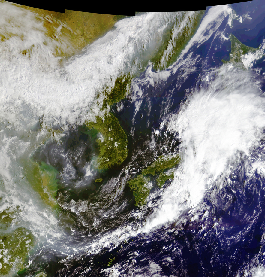
GOCI pseudo-colour RGB composite image using GOCI bands 1, 4 and 6, generated from the GOCI Level 1B test result acquired on September 16, 2010. (Click on image to enlarge) Currently, in-orbit performance verification tests of GOCI's image navigation and registration system is in progress by Astrium and KARI. From November, KORDI plans to carry out the performance test and verification of the GOCI Data Processing System (GDPS), which processes ocean environment products such as chlorophyll concentration, dissolved organic matter, turbidity etc. The beta version of GDPS S/W is scheduled to be released in January next year after a brief vicarious calibration with in-situ measurement data. GOCI data distribution service from KOSC (Korea Ocean Satellite Center) website (http://kosc.kordi.re.kr) will be opened officially early next year, after completion of GOCI in-orbit tests.
Several new references have been added to the IOCCG Recent References list, including a paper by by Daniel G. Boyce et al. published in Nature (2010) entitled "Global phytoplankton decline over the past century". The authors compiled publicly available in situ surface Chlorophyll and ocean transparency measurements (i.e. standardized Secchi disk) from 1899 to present, and synthesized all available information to assess long-term changes in phytoplankton biomass at local, regional and global scales. 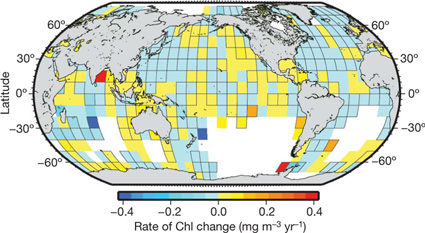 They observed statistically-significant decreases in Chlorophyll concentrations for eight out of ten ocean regions, and estimated a global rate of decline of ~1% of the global median per year. These findings are consistent with recently observed declines in remotely-sensed chlorophyll concentrations. Their analyses further revealed interannual to decadal phytoplankton fluctuations superimposed on long-term trends. These fluctuations are strongly correlated with basin-scale climate indices such as the El Ni�o Southern Oscillation (ENSO) and the North Atlantic Oscillation (NAO), whereas long-term declining trends were related to increasing sea surface temperatures. They noted that the negative effects of SST on Chl trends were particularly pronounced in tropical and subtropical oceans, where increasing stratification limits nutrient supply. Their findings are consistent with the hypothesis that increasing ocean warming is contributing to a restructuring of marine ecosystems, with implications for biogeochemical cycling, fishery yields and ocean circulation. |
|
Material for possible inclusion in the IOCCG Newsletter should be submitted to the Project Scientist, Dr. Venetia Stuart
Subscription to the IOCCG Mailing List. Participants receive a brief summary of the IOCCG Newsletter by e-mail (quarterly), as well as hard copies of IOCCG Reports as, and when, they become available.
|
|
|
|