|
|
|
The final version of the PRESPO IOCCG Handbook of Satellite Remote Sensing Image Interpretation: Applications for Marine Living Resources Conservation and Management is now available for download from the IOCCG website at: www.ioccg.org/handbook.html (no hard copies, only digital files). This handbook is intended as a web-based educational/ training document oriented towards the interpretation of satellite images derived from data freely available from various space agency archives. The final version of the handbook contains 19 case studies prepared by specialists in their respective fields, and arranged in four different themes: air/water quality, phytoplankton & macroalgae, fisheries & aquaculture, and marine ecosystem characterization. The case studies demonstrate the processing, interpretation and application of a wide range of satellite data (including ocean colour data).
A meeting of the Chlorophyll Globally Integrated Network (ChloroGIN) took place at the Bedford Institute of Oceanography from 9-11 August 2011. ChloroGIN is an international network to assess the state of marine, coastal and inland-water ecosystems for the benefit of society, promoting in-water observations in synergy with ocean-colour and related satellite observations. ChloroGIN is funded by the Canadian Space Agency under the terms of the FARO Project (Fisheries Applications of Remotely-Sensed Ocean Colour). Representatives from the various ChloroGIN nodes as well as other invited participants attended the workshop. Updates on the status of the ChloroGIN nodes were presented, i.e. Europe, Indian Ocean, Antares (Latin American node), Africa, Canada, and NE Asia, as well as global ChloroGIN. Break out discussion groups examined the feasibility of establishing a ChloroGIN-lakes node (see demonstration link on ChloroGIN website), as well as a node for SE Asia. ChloroGIN has close ties with GEO (Group on Earth Observations) and subscribes to the new transverse task on Oceans and Society: the Blue Planet, which targets the "Societal Benefit Areas" of Water, Climate, Ecosystems, Biodiversity and Agriculture. In addition, the status of a proposal submitted to GEO for expanding various ChloroGIN activities was reviewed by a representative from the GEO secretariat. Workshop participants also discussed ways of improving in situ data availability and sharing, and updates to the ChloroGIN website (hosted by the Plymouth Marine Laboratory).
A meeting of the IOCCG Executive Committee took place from 8-9 September 2011 at the Laboratoire d’Océanographie de Villefranche (LOV) in Villefranche-sur-Mer, France. The Executive Committee discussed various pressing matters including:
The National Research Council of the National Academy of Sciences (USA) recently produced a report from the committee Assessing Requirements for Sustained Ocean Color Research and Operations (2011). Their key findings were that all current NASA sensors are beyond their design life. The committee concluded that VIIRS (planned for launch in Oct 2011) will only produce high-quality ocean colour data if a series of improvements are made (e.g. implementing a monthly lunar view, supporting a MOBY-like vicarious calibration approach, and building the capability to process and reprocess ocean colour data at NOAA). The committee recommended that NASA and NOAA could work in partnership to produce, archive, and distribute data of shared interest. Non-US sensors could augment data for US users if data-exchange agreements were immediately pursued. The committee also concluded that the data requirements for ocean colour applications are so diverse that a single satellite sensor or space agency cannot meet all ocean colour needs. An international collaborative effort combining the many sensors planned for the future could help meet the diverse demands of the ocean colour community. To read this report, see the National Academies Press website.
Several new positions have been added to the Employment Opportunities section of the IOCCG website, including ten PhD positions at the Université Laval (Canada), two post-Doctoral positions for the “BOUSSOLE” project (France), two Research Oceanographer Positions at NOAA (USA) and a PhD position at the University of Victoria (Canada). |
Level-1 and Level-2 reduced resolution (RR) global data from the latest MERIS reprocessing is now available. The MERIS 3rd reprocessing has been completed and the data are available online via ftp at the UK-PAC. The ftp site currently includes the full 2008 to 2010 Level-1 and Level-2 reprocessed dataset. The entire reprocessed dataset from 29 April 2002 to date will gradually be made available online over the coming weeks. Address and access to the ftp site can be provided to existing ESA proposals and/or registrations by request to the EO Helpdesk (eohelp@esa.int) or through a new registration on the ESA EOPI Portal. For further details and documentation see the ESA Earthnet Online webpage. Questions can be sent to eohelp@esa.int or posted on the ODESA Forum.
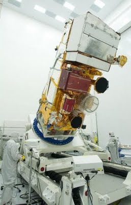
The National Polar-orbiting Operational Environmental Satellite System Preparatory Project (NPP), the first of a new generation of satellites that will observe our changing Earth, recently arrived at the Vandenberg Air Force Base in California to begin preparations for a scheduled 25 October 2011 launch. NPP is the first satellite mission to address the challenge of acquiring a wide range of land, ocean, and atmospheric measurements for Earth system science while simultaneously preparing to address operational requirements for weather forecasting. NPP serves as a bridge between NASA's Earth Observing System of satellites and the forthcoming Joint Polar Satellite System (JPSS) which will be developed by NASA for NOAA. NPP will carry five science instruments including the VIIRS (Visible Infrared Imaging Radiometer Suite) instrument which will provide data for measurement of cloud and aerosol properties, ocean colour, sea surface temperature etc. The VIIRS spectral coverage will allow for data products similar to those from SeaWiFS as well as SST measurements. Goddard manages the NPP mission on behalf of the Earth Science Division of the Science Mission Directorate at NASA Headquarters in Washington, and NOAA will provide operational support for the mission. Launch management is the responsibility of the NASA Launch Services Program at the Kennedy Space Center in Florida.
Several new references have been added to the IOCCG Recent References list, including a paper by P. Shanmugam (2011) entitled New models for retrieving and partitioning the colored dissolved organic matter in the global ocean (Remote Sens. Environ. 115: 1501–1521). The author developed a new approach for accurate modelling of absorption spectra of CDOM (acdom) and for deriving information on its composition in global ocean waters. The robustness of this model was rigorously tested on three independent datasets and the accuracy of the retrievals was found to be excellent. When used with SeaWiFS images collected over regional and global waters, the new model showed the highest surface concentration of CDOM within the subpolar gyres and continental shelves which are dominated by terrestrial inputs (and perhaps local production) of CDOM, and the lowest surface concentration of CDOM in the central subtropical gyres and the open oceans, presumably regulated by photobleaching phenomenon, bacterial activity and local processes. Significant interseasonal and interannual changes in the terrestrially-derived CDOM distributions were noticed from these new products that corresponded closely with the global mean runoff/river discharge induced by climate change/warming scenarios. The results have important implications for ocean colour research and provide exciting opportunities for remotely assessing ocean biological and biogeochemical processes.
The second paper is by Laura Lorenzoni et al. (2011) entitled Bio-optical characteristics of Cariaco Basin (Caribbean Sea) waters (Cont. Shelf Res. 31: 582-593). The authors assessed monthly bio-optical properties between 1995 and 2005 as part of the CARIACO Ocean Time-Series program. Temporal changes in light quality and penetration were caused by seasonal variations in the concentration of three major optical constituents, i.e. phytoplankton, detrital particles and CDOM. All constituents showed higher absorption coefficients during the upwelling season (Jan–May), compared to the rainy season (June–Nov). CDOM dominated light absorption during the rainy season, which led to an overestimation of SeaWiFS-derived chlorophyll concentration during this period. During upwelling, the highest Chl-a concentrations (>1 mg m-3) were observed in the upper 25 m, with primary production rates exceeding 1800 mg C m-2 d-1. During the rainy season, low Chlorophyll-a concentrations (< 0.2 mg m-3) persisted near the surface and primary production values dropped by about half. This work reports long-term ecosystem changes in the Cariaco Basin which are reflected in bio-optical properties at the CARIACO time series station. These new results further our understanding of the oceanography of the Caribbean region and highlight the importance of time series in trying to understand ecosystem and functional group changes in the ocean. It illustrates the utility of in situ and satellite optical measurements to assess complex processes in the ocean.
|
|
Material for possible inclusion in the IOCCG Newsletter should be submitted to the Project Scientist, Dr. Venetia Stuart
Subscription to the IOCCG Mailing List. Participants receive a brief summary of the IOCCG Newsletter by e-mail (quarterly), as well as hard copies of IOCCG Reports as, and when, they become available.
|
|
|
|